Google has been busy injecting AI-powered features into all of its services this year, and some of the most promising are in Google Maps. Well, this week those features – including the long-awaited Immersive View for Routes – are going to start rolling out on your Android or iOS phone, alongside some new tricks.
The biggest news is the rollout of Immersive View for Routes in 15 cities, starting this week. The feature combines Street view, aerial imagery, and live information like weather and traffic to give you an aerial, photo-realistic preview of your planned Google Maps route – so we’re excited to take it for a spin soon.
Google’s machine learning algorithms are also improving other parts of the Google Maps experience, including its Search function and the AR-powered ‘Lens in Maps’ feature, which overlays useful labels on buildings you’re pointing at with your phone’s camera.
In short, whether you’re a lost pedestrian or an electric car driver, Google Maps is about to get even more useful. Here are the five main AI-powered updates that are coming and when they’re expected to roll out.
1. Immersive View for Routes is finally rolling out
- Rolling out this week on Android and iOS in 15 cities
Google Maps’ Immersive View has had a frustratingly slow rollout since it was announced back in May 2022, but the feature is starting to become more widely available – and the more recent Immersive View for Routes will be rolling out on Android and iOS in 15 cities this week.
If you haven’t tried it, Immersive View combines Street View, satellite, and live data to create a real-time aerial view of famous landmarks in supported cities. In May, Google announced Immersive View for Routes, which gives you the same impressive visuals for any routes that you’re planning, making it much more useful.
Well, this week the feature is finally rolling out in the 15 cities Google mentioned back in May: Amsterdam, Barcelona, Dublin, Florence, Las Vegas, London, Los Angeles, Miami, New York, Paris, San Francisco, San Jose, Seattle, Tokyo and Venice.
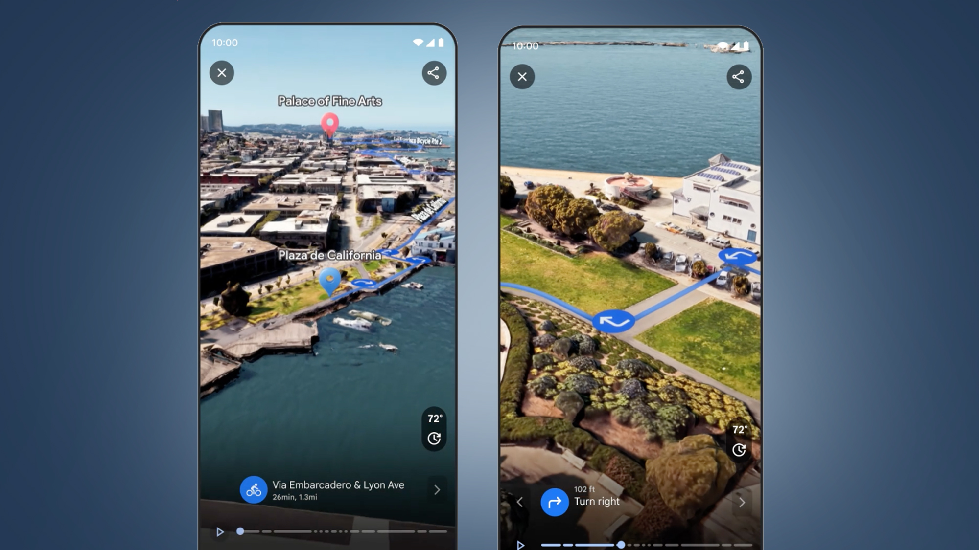
It isn’t yet clear if this will be available for every route you plan in Google Maps in those cities, or select parts of the city. But to use it, all you’ll need to do is tap the Immersive View for Routes card in the bottom-left corner of any route you have planned in the Maps app.
With simulated weather and traffic conditions (the latter being predicted based on historical data) overlaid on top of the 3D view, it should give you a good idea of whether that bike ride route is looking like a good one today.
2. Maps Search is getting more helpful
- Photo-first results roll out this week in the US, UK and more
- Thematic results rolls out this week globally on Android and iOS
Considering Google is still the king of search, Google Maps’ search function isn’t quite as powerful as it could be – but that’s about to change this week.
Google says it sees millions of broader searches in Google Maps, like “animal latte art” or simply “things to do around me”, so it’s bringing a couple of updates to help with those. The first is photo-first results for searches, which will come from an AI-powered analysis of billions of photos shared by Maps users.
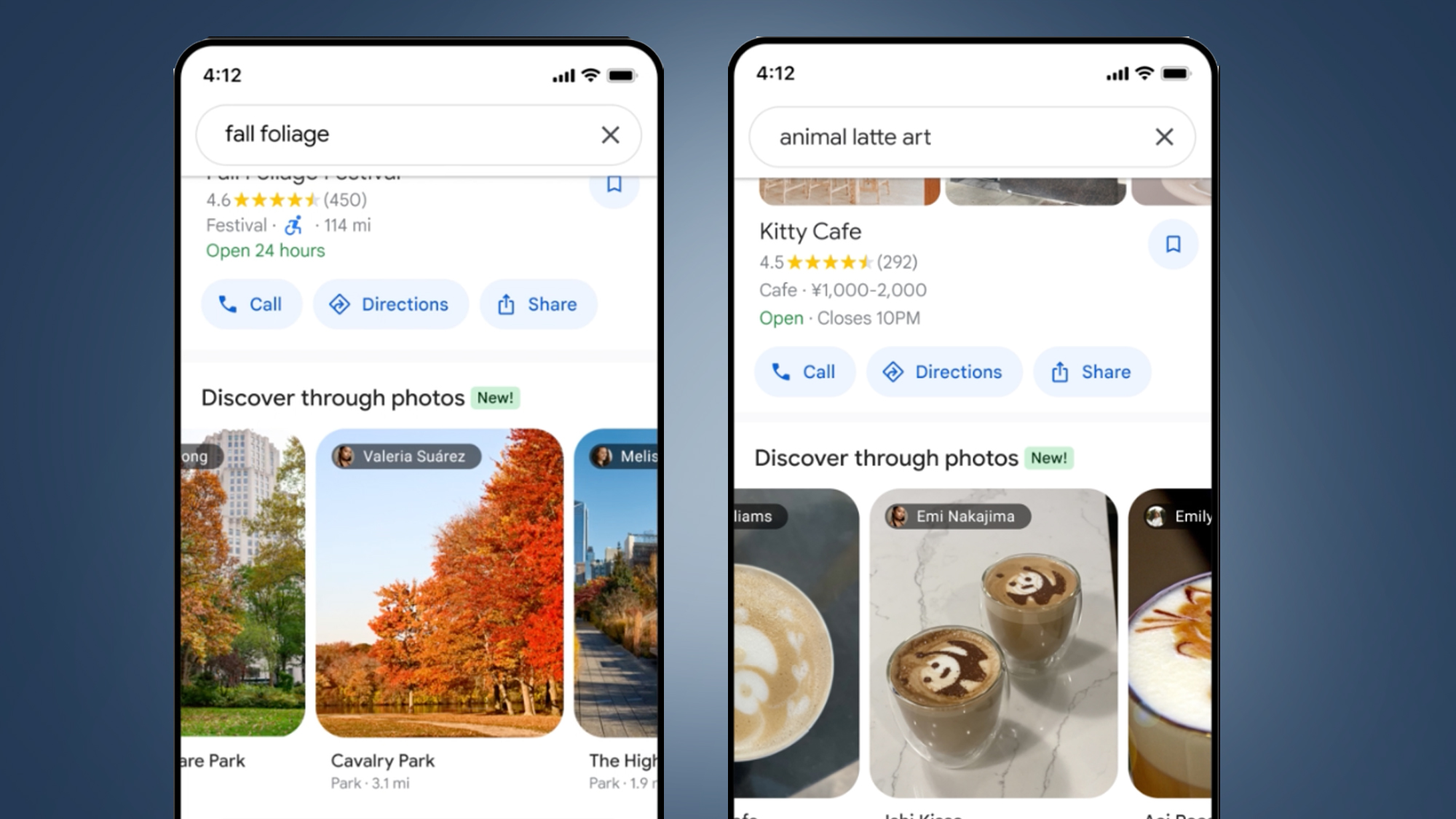
Rather than simply showing you cafes with ‘animal latte art’ in their name or reviews, it’ll use this image analysis to give you a list of photo-based results, too. Pick your favorite from the images and it’ll give you more info and directions. This feature is rolling out this week in the US, UK, France, Germany and Japan.
The other update, rolling out globally on Android and iOS this week, will help answer those broader ‘things to do’ searches. Rather than a long list of results, you’ll now see themes appear in Google Maps search results (like ‘art exhibitions’ or ‘anime’), which promises to make it more like a Maps-based Time Out guide.
3. Google Maps’ AR mode spreads its wings
- Lens in Maps comes to over 50 new cities this week
Did you know that Maps has a built-in Google Lens feature that can label things around you using your phone’s camera? This used to be called ‘Search with Live View’, but Google now calls it ‘Lens in Maps’ – and this week the feature’s coming to over 50 new cities.
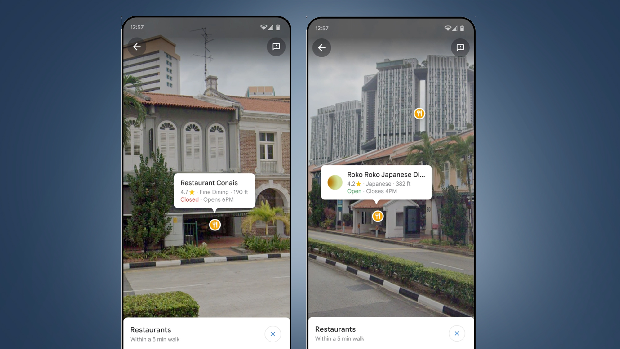
If you’re feeling completely bamboozled in a new area, it’s a handy feature – just tap the ‘Lens’ icon in the Google Maps search bar on Android or iOS. That opens a live camera view, so you can spin around and see what Google Maps has labeled in your immediate surroundings, like restaurants, ATMs, stations, or landmarks.
This AR-powered feature (which sounds ideal for some AR glasses, like Google’s rumored Project Iris revival) is coming to dozens of new cities including Austin, Las Vegas, Rome, São Paulo, and Taipei. So look out for it on your next holiday.
4. Driving navigation will soon get clearer
- improved navigation coming in “the coming months” to 12 countries
If you regularly use Google Maps as your in-car sat-nav, you’ll be pleased to hear that some navigation improvements are coming down the road – well, in the “coming months” at least.
Google says these improvements will include “improved lane details” (like the below) to help you know exactly when to get off the highway, along with some more realistic buildings to help you pinpoint exactly where you are.
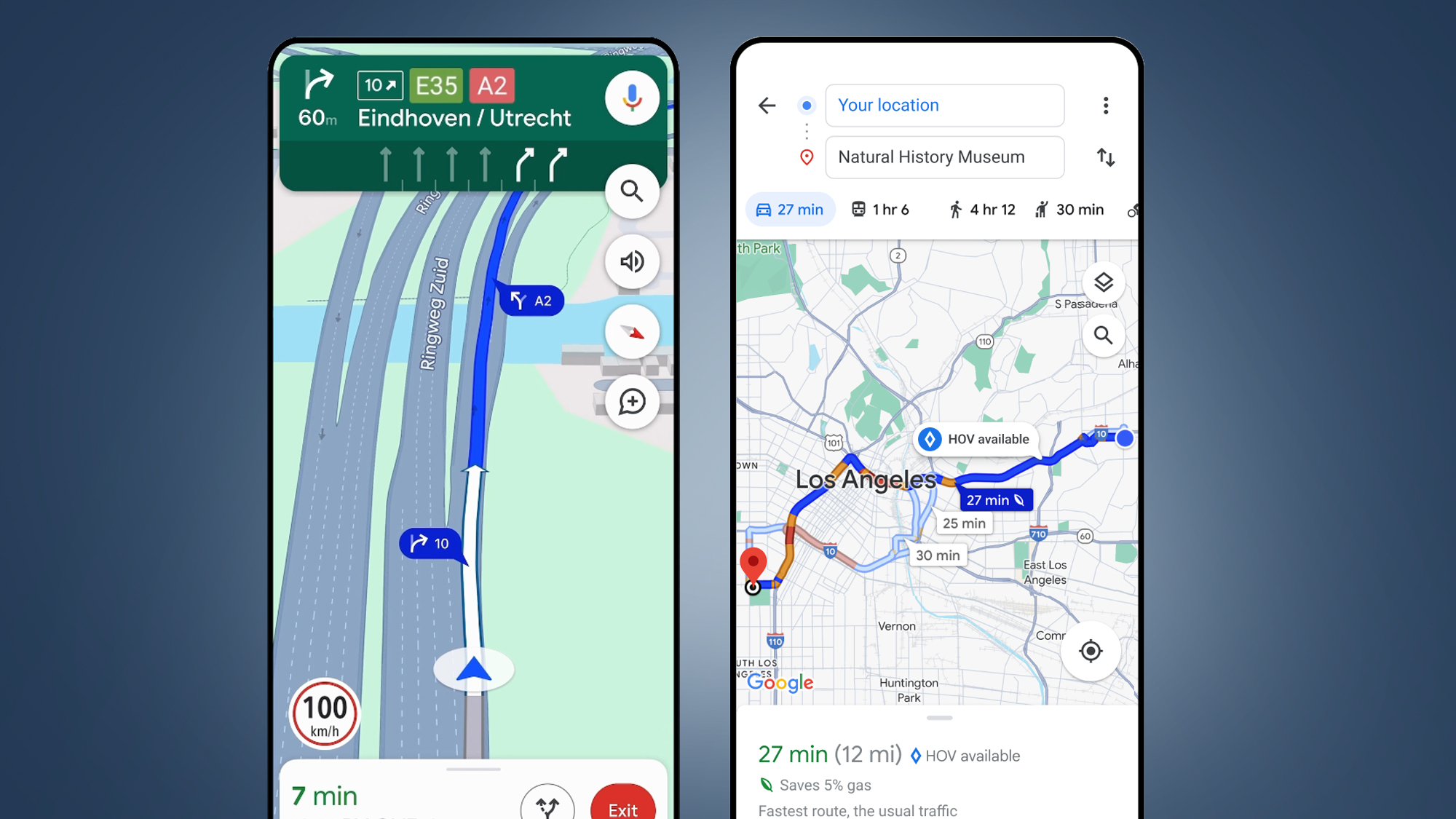
In the US, you’ll also soon see HOV (High-occupancy vehicle lanes) on your route, while in Europe 20 new countries will soon get Google’s AI-powered speed limit information.
These Maps navigation improvements for drivers will be rolling out in the “coming months” in 12 countries, including the US, Canada, France, and Germany. That timeframe can mean a wait of 3-6 months, but it’s something to look out for.
5. More helpful EV charger info is en route
- Rolling out this week on Android and iOS
If you have an electric car, you’ll have been happy to see Google Maps’ recent improvements to its charging station information – and that info will soon be getting a lot more detailed and useful.
Later this week on Android and iOS, Google says its charging station information on Maps will now include whether a charger is compatible with your car and how fast the chargers are, too.
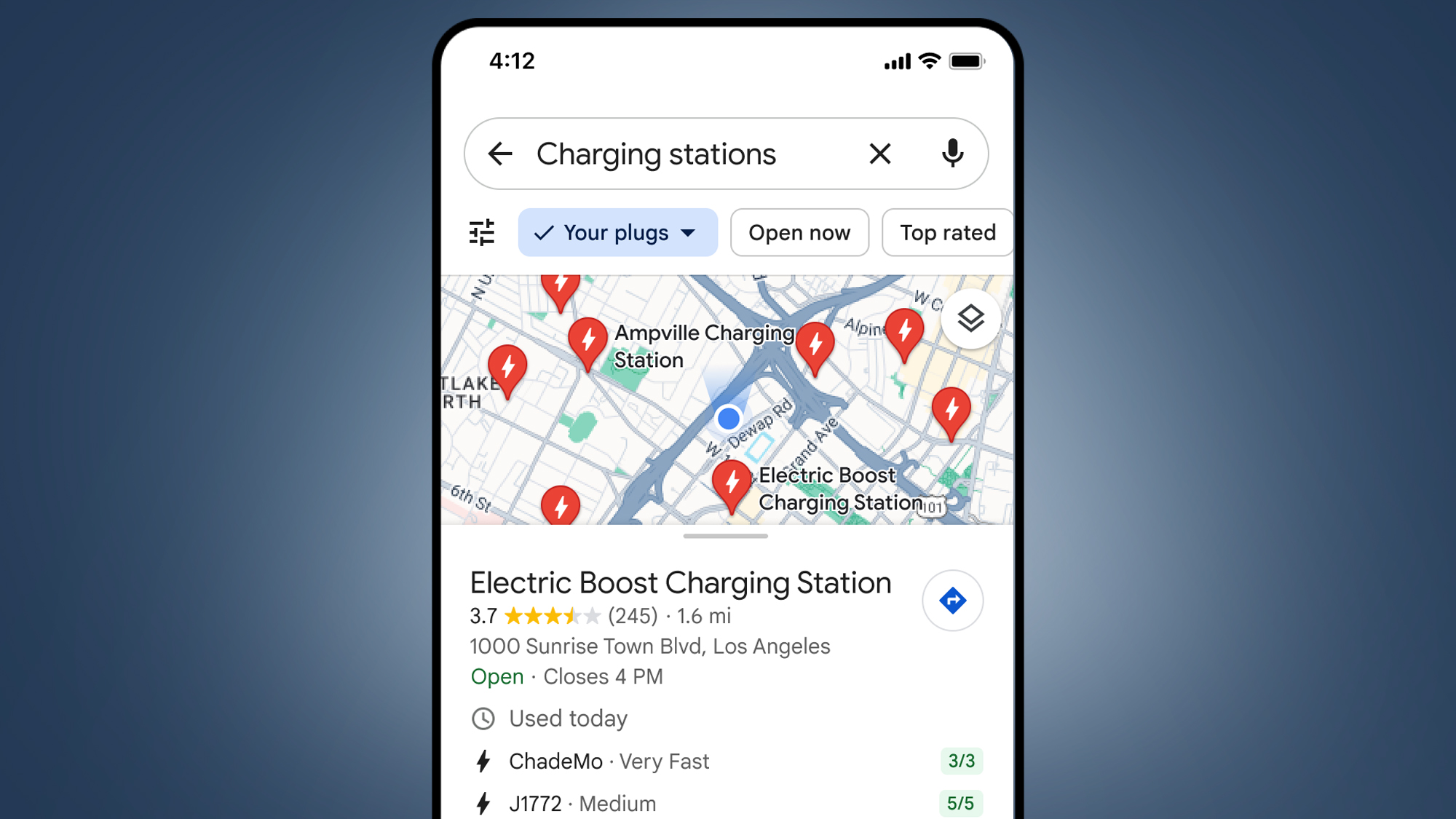
Perhaps most impressively, Maps will also show when the charger was last used – which will help you decide whether it’s likely to be one of the many that’s currently not working.
Google says that 25% of EV chargers in the US are down at any given time, so this feature promises to be a potentially big time-saver (and stress reducer).


